When Hurricane Ida ravaged Louisiana’s coastline last month on the 16th anniversary of Katrina’s carnage, everyone wondered if the region’s levies and infrastructure improvements would make a difference. While the storm surges were managed better this time around, the economic damage for households and businesses will still have a deleterious effect on an already challenging situation for tens of thousands of Louisianans.
According to the United Nations, it is one example of the “climate apartheid” that will impoverish more than 120 million people by 2030. The question for Virginia and other coastal states is less about the inevitability of sea level rise and more about how they wish to be written into the narrative the UN sees unfolding for generations to come. The future is certain, in some ways, and up for grabs in others. The 2020 Virginia Coastal Resilience Master Planning Framework offers some clues as to how the Commonwealth’s future might pan out.
The framework is the product of almost two years of work by state agencies, scientists, and administrators to outline a plan to protect coastal communities that centers on working with nature rather than against it in absorbing sea level rise. The framework also seeks to “ensure equity for underserved communities” by drawing on recently acquired data about African-American and Native American coastal communities and their physical and economic risks, and recommending relocation in some cases. Notably, the framework cites the Community Flood Preparedness Fund’s 25 percent set-aside as a way to address environmental justice for the most disenfranchised coastal communities, among other funding mechanisms.
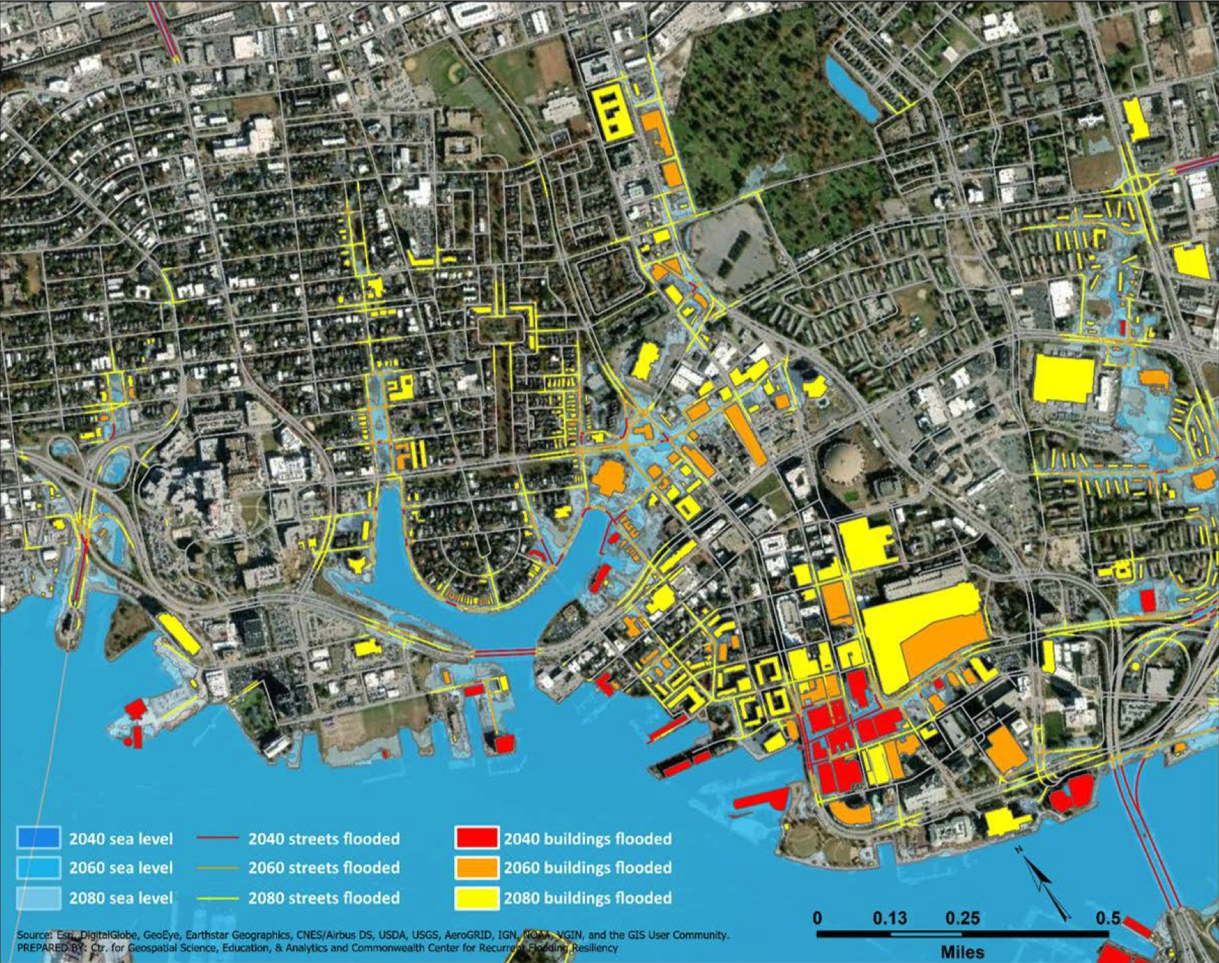
In some ways, the Virginia Coastal Resilience Master Planning Framework presages the Biden Administration’s 2021 Bipartisan Infrastructure Investment and Jobs Act, representing $550 billion investments in resilience and water infrastructure, not to mention roads, bridges, and digital networks. However, Virginia’s framework is not an investment, per se, but a strategy that may lead to an actionable plan. It’s most significant goals center on strengthening “partnerships” and “building state government capabilities,” rather than measurable impacts on communities. For this reason, critics say that the framework is, at worst, toothless and, at best, far too little too late. Others say that it’s the necessary step to unify the dozens of counties and municipalities that touch more than 10,500 miles of coastline, tidal bays, non-tidal bays, and inland bays and lagoons. Within those areas, the framework notes, more than 421 square miles of land across eight coastal planning districts will be permanently inundated by water in 2040, which is nearly the size of the city of Virginia Beach.
There is another way to interpret this strategy document, however, and that’s as an opportunity for architects working across Virginia to evaluate how they work in rural and urban coastal communities. Increased rainfall due to climate change might be inevitable, but stormwater management across all building types is not, and there are creative solutions that can mean savings for the client in the long run. Increased costs associated with weather-related delays in the materials pipeline may be mitigated through different sourcing choices that are closer to the job site that, in turn, reduce the carbon produced by transportation. Forging a closer partnership with landscape architects to specify permeable surfaces in site planning can offset the long term liabilities associated with construction in a sensitive coastal zone.
Beyond its practical adaptations, there is a political reality to the Virginia Coastal Resilience Master Planning Framework that bears mentioning. Neither the word “architecture” or “architect” is mentioned once in 314 pages (although, to be fair, phrases like “design for state-owned buildings” or “adaptive designs below the lowest floor” appear a few times). Perhaps these omissions shouldn’t matter in a strategy document as much as the impact of architectural commissions matter in the long run. But, the long run is not just about a new physical landscape adjacent to 10,500 miles of coastline, bays, and lagoons. It’s also about a new economic landscape for architecture firms that will evolve over the next 20 to 50 years, making this strategy document a valuable asset for any firm looking to the future.
About the author
William Richards is a writer and editorial consultant based in Washington, D.C. From 2007 to 2011, he was the Editor-in-Chief of Inform Magazine.